Distance : East Falls – 1.5 km, West Falls – 2 km
Elevation Gain : East 300 m, West 330 m
Difficuty : East – Moderate to difficult, West – moderate
These trails offer a moderately strenous uphill effort to the tall, cascading falls. The first part of the trail goes through a unique and interesting forest swamp ecosystem and the trail is elevated on a pleasant 250 m long boardwalk. The west falls trail veers right and the east falls trail goes to the left. The trails are identifiable by ribbon and use.
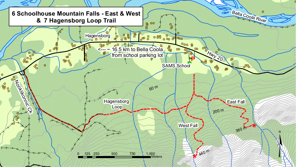
At the end of both trails are great views of the Hagensborg area, lower Bella Colla Valley, the massive granite faces on the opposite side of the valley , including Saloomt Peak and Salloompt River valley opposite right, Mill Creek opposite left and four Mile ridge above the airport.
The east trail is somewhat steeper and cruder but the falls are more impressive than the west falls. You can edge out at the bottom of the falls and this is a great finish if you do want to carry on and scale the steep rock near the top of the falls. The West Falls trail is a mixed difficulty trail with easy sections and a steeper cimb at the end. The falls at the end of the trail are a series of small cascades.
How to get there
Park at the Sir Alexander Mackenzie Secondary and Nusatsum Elementary School parking lot located in Hagensborg (16.5 km from Bella Colla on Hwy 20). Walk between the schools to the south side of the sports field. The trail starts at the edge of the forest near the center of the field at the boardwalk.