Background Information
Planned operations currently on hold pending further community engagement.
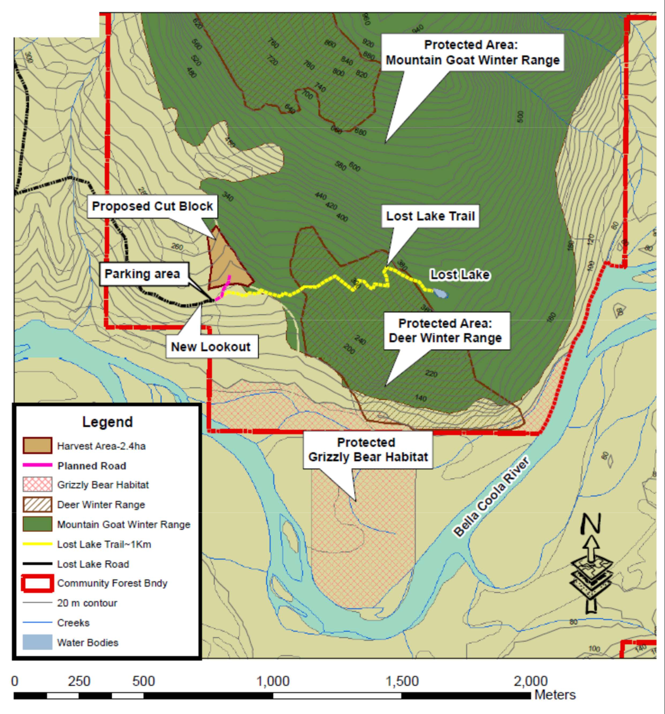
Harvest operations are planned on the Bella Coola Community Forest at the end of the Lost Lake Forest Road near the start of the Lost Lake trail. The harvest area is small (2.4 ha) and operations will only be active for a few weeks. To access the area, the road needs to be extended along the first 30 m of the trail (which is an old logging road at this point) and then veers off the trail to the north.
A treed buffer will be maintained between the trail and the harvest area. The trail and parking lot will remain open for public use throughout the duration of operations. A fire burned this area about 110 years ago and the majority of the stand is now comprised of thrifty cedar, Douglas-fir and hemlock that regenerated naturally following the fire. There are a few large veteran Douglas-fir and cedar trees that survived the fire and of these, the plan is to leave the larger, majestic specimen standing. Given that these trees have towered over the younger canopy for the last 100 years, they are expected to be windfirm.
A few years ago, there was significant amount of windthrow of the younger timber along the west boundary and it is good stewardship to salvage windthrow when possible. In order to cover the cost of mobilizing equipment, repairing and brushing the Lost Lake forest road and constructing the short access spur, some adjacent timber needed to be included for the project to be viable.
Concerns have been raised that due to the presence of the large veteran trees, the stand should be
considered old growth and preserved. However, there are larger more intact representations of old growth ecosystem further along the Lost Lake trail.
Ungulate Winter Ranges
The block was also located to avoid important mountain goat and deer winter ranges to the east and north. Winter ranges are critical for long term sustenance of ungulate populations and most of the forest on the south side of Salloompt peak and surrounding Lost Lake is formally protected mountain goat and deer winter ranges. Resource development is not permitted in these areas and adjacent areas are subject to noise restrictions during winter periods. Winter ranges are forested lands with certain characteristics that help ameliorate winter conditions so that ungulates can survive periods of cold, low browse supply and deep snow. Winter ranges contain features like south facing slopes that are warmer, dense forest canopy that intercept snow and retain heat and a forest floor that provides browse vegetation while permitting escape mobility.
Additional habitat protection in the area includes lands set aside for grizzly bear habitat, which is
located on rich valley bottom flood plain.
Proposed Lookout Location
The Bella Coola Community Forest plans to open a lookout over the valley near the parking lot by pruning branches and cutting a few young trees. This will become the only elevated viewing site in the valley that is readily accessible by car, thus making it possible for people that are not able to hike the local trails to get to view the valley from above. A picnic table may also be installed to add to the experience. Furthermore, the Lost Lake Forest Road is in much need of maintenance work to fill potholes and roadside brushing which will be undertaken as part of the operating plan.

Please contact our office at 250-982-2131 if you have any questions about our planned operations.


