East Trail
Distance : 5.4 km
Elevation change : 50 m
This trail undulates through second growth forest and was developed for mountain biking but provides a pleasant shaded walk on a hot day. The East loop takes off from the south loop and heads east on to private land and ends at Hwy 20. The trail is maintained by the property owner so please respect their goodwill by practicing courteous trail etiquette.
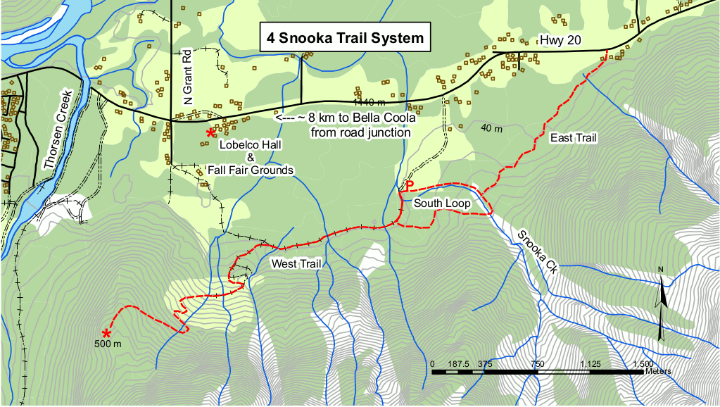
How to get there
Turn on to the Snooka Forest Service Road, approximatey 8 km east of Bella Coola (across from Barb’s Pottery) on Hwy 20. Follow the forest service road for 0.5km to the parking area. A signboard has a map of the area trails.
South Loop
Distance : 1.7 km
Elevation change : 50 m
Difficuty : Easy to moderate.
A pleasant shaded walk on a hot day this trail provides more vegetation variety than on the East Trail as it starts in second growth forest then meanders to an old growth cedar stand. There used to be a bridge across Snooka Creek but it was washed out in a major flood event a few years ago, so this part of the trail is no longer a loop.
How to get there
Access is the same as the East Loop.
West Route
Distance : 3.8 km
Elevation : 500 m
Difficuty : Moderate
The west trail features scenic views of Bella Colla and the Four Mile residential area, historic Tallheo Cannery and North Bentinck Arm. The viewpoint also looks down on Thorsen Creek and the site of the petroglyphs. The lower trail is an old road but cattle and horses use this area and the trail is therefore only for hiking.
How to get there
Access is the same as East Loop.